

{Shikoku Hachijūhachikasho Meguri}
--PREPARATIONS--
--READING JAPANESE MAPS--
--PREPARATIONS--
--READING JAPANESE MAPS--
For those of you who can read and write kanji with no problems, you can skip this page. For the rest, you are going to have to figure out how to get around the island with directions that are entirely written in those pesky, hard to read Chinese characters. On the one hand, i'll say up front that it is going to be a challenge. On the other hand, challenges are a good thing — right? I believe that if you learn several dozen critical, survival kanji, you will get by with a minimum amount of trouble.
There are two issues here, i think: how to read the maps that take you around the island and how to read the signs and markers on the side of the road/trail as you walk. With the release of the English guidebook Shikoku Japan 88 Route Guide in late 2007, the first issue has been eliminated. If you choose to use the Japanese maps (Shikoku Henro Hitori Aruki Dōgyō Ninin), though, you will need to learn how to read the kanji below.
There are a number of very common landmarks that are used throughout the Japanese mapbook AND around the island on signage you'll see on the trail markers, on the roads around the temples, and at the temples themselves. If you can read these kanji, it makes it a lot easier to mark your progress on the maps and to look for these landmarks when you need to make a turn, look for a trail head, or find your lodging. If you learn to read and write the below kanji before you leave, your life will be much easier. Don't worry about how pretty you can write them, or whether or not you know how to pronounce them — treat them as hieroglyphics and just be able to interpret them wherever you see them, both on a map and on the side of the road.
Numbers
To start off you need to know the numbers. Luckily, most of the road signs in Shikoku, and a lot of the telephone numbers, are written in arabic numerals (1, 2, 55, etc.). That means that finding streets and watching for intersections where you need to make a turn is that much easier. In addition, on the maps all temples are numbered with arabic numerals. The main highways on the maps are numbered with a combination of arabic numerals and kanji, as will be explained below.
However, all signs pointing the way to the temples will use kanji numerals. The signs at the temples are written in kanji, and the numbers in your stamp book are in kanji. Here are the numbes from one to ten:
To make numbers greater than ten, just add combinations of these numbers. For example, if you want to write the number 23, you add two tens and a three. Or, to write the number 85, you add eight tens and a five.
Temples
Next you need to know how to write the words Tera (Temple), Hondō (Main Hall), and Daishidō (Daishi Hall). These are, respectively:
There are two more kanji that you need in order to understand the signs you will see for temples. These are Dai and Ban. Dai is a prefix that goes in front of numbers and can usually just be translated as "The." Ban, is a suffix that means "number." The kanji for Dai and Ban, respectively, are:

Given all the above, Temple 43 would be written as, Dai 43 Ban Tera, The 43 Number Temple:
While you won't see this next kanji on any of your maps, you will need to look for it at each of the temples before you leave. The "Nōkyōjo" is the office where you get your Nōkyōchō (stamp book) stamped and signed just before leaving. There is always a little sign somewhere in the compound pointing the way to the office.

Highways
The major highways are numbered on the map with Arabic numbers, but the "Natioanl Highway" part is written in kanji. To read highway numbers you need to be able to read three kanji: Koku (National), Dō (Road), and Gō (Number).
Put together, Natioanl Highway # 55 (or just National Highway 55) would be read "Koku Dō 55 Gō," National Road 55 Number. The kanji for National Highways 439 and 55 would then look like:

Note: In the 2004 printing of the guidebook the highways are all written with Arabic numerals, like westerners are used to seeing them, with the shape of the symbol indicating if it is a major highway or a smaller prefectural highway. The signs on the side of the road are written in Arabic numerals as well. You may only need to know this section for those times when someone gives you a hand-drawn map or if you happen to be using an older version of the guidebook.
Gas Stations
A very common landmark, and one that you will use all the time, is the gas station. This is written in two different ways in the maps. One way is the generic Gasorin sutando (literally, Gasoline Stand). The other is to call it a Sekiyu sutando (literally, Oil/Petroleum Stand). The kanji for these are, respectively:

You will see these landmarks on almost every page in the map book.. Sekiyu sutando is the more widely used of the two and both are always prefixed with the name of the station.
Note: In the 2004 printing of the guidebook, it looks as if they removed the names of the gas stations and only mark them with an icon (see below). You may only need to know this section for those times when someone gives you a hand-drawn map or if you happen to be using an older version of the guidebook.
Restaurants and Grocery Stores
Restaurants and other places to eat are also found throughout the mapbook. These are useful as landmarks or when trying to plan where to stop and eat. Some of the words you should learn to read are Resutoran (Restaurant), Supa (Grocery Store. Literally, Super, from supermarket), Konbiniensu (Convenience Store), and Kissaten (Coffee Shop). The kanji for these are:

While there are exceptions, Resutoran and Supa are usually followed by the business name. I don't see Kissaten, by itself, in the mapbook, but you will see it on the side of the road a lot. Learn to recognize it and you can stop for snacks, sandwiches, tea & coffee. However, Kissa, the first part of this word, is used on some of the maps with a suffix of the business name. Examples of these in the pre-2004 printing of the mapbook are: Resutoran (page 164), Supa (page 97), Konbiniensu (page 127), and Kissaten (page 112).
Note: In the 2004 printing of the guidebook, many of the restaurants and grocery stores thar are shown on the maps have changed, so the above examples are no longer valid. I guess some have gone out of business, some have decided they don't want to be listed, or new ones have opened up. In any case, you can always find them by looking for the appropriate icon (see below) on the maps.
Minshuku, Ryokan, and Business Hotels
The three most common types of lodging, other than the temples themselves, are Minshuku (Traditional Inn), Ryokan (another type of Tradition Inn), and Bijinesu Hoteru (Business Hotel). The kanji for these are, respectively:

These are found throughout the mapbook, and examples include: Minshuku Asuka (top of map 5), Fujiya Ryokan (middle of map 4), and the Orient Buisness Hotel (center of map 7). In addition, the last dozen pages, or so, of the mapbook are a listing of minshuku, ryokan, hotels, and business hotels, with their address and phone numbers. Use this list to find your next days lodging and plan how far (or little) you need to walk.
Note: In the 2004 printing of the guidebook, page numbers and the layout have changed from previous printings. In the pre-2004 printings, Minshuku Asuka is on the bottom right of page 101, Fujiya Ryokan is on the bottom right of page 98 , and the Orient Buisness Hotel is in the center of page 102, but listed as the Business Hotel Orient.
Train and Bus Stations
Note: In the 2004 printing of the guidebook, the way train and bus stops are indicated has changed quite a bit. In fact, train lines and stations are much more clearly depicted with stations indicated as white rectangles right on the train line with their name written next to them in hiragana. This section pertains to the pre-2004 printings.
Train and bus stations are more important that many walkers realize. Where they exist, there are a lot of signs pointing the way to them. That makes them great landmarks even before you get to them. In addition, if you are looking for a phone with a data jack in order to check email, a good bet is that you will find one in front of the train stations.
Japan National Railways has a monopoly on trains and busses on Shikoku so all you need to do is learn to read JR (the standard abbreviation for Japan National Railways), Eki (Train station), and Basu (Bus). These are:
For train stations, the format will almost always be JR XX Eki, with the name of the train station replacing the XX, and for bus stations, JR XX Basu, with the name of the bus station replacing the XX. So, learn to recognize the JR at the front and then look at the end to see if it is Eki or Basu, ignoring everything in between. Examples include the JR Honzan Train Station in the center of page 166 (just above Temple 70) and the JR Shikoku Bus Station (on the bottom left of page 165).
And, finally, to help you make sense of the map book, this is a translation of the legend from page 9 of the 2004 printing of the Japanese version of the guidebook itself. In the end, you may be able to get by simply by looking for these icons as you go along. In my opinion, though, knowing how to read the above kanji will make it easier to spot the actual building once you get in the vicinity — in fact it may be the only way.
{Note: I wrote this page before the English version of the guidebook was published. Since most, if not all, people who can't speak Japanese will now use that English version, the legend isn't really needed. I'll leave it here just in case, however.}
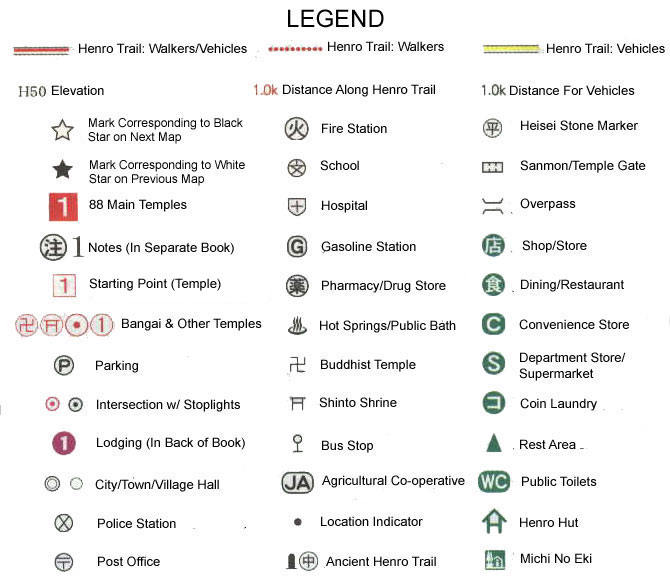
 in the legend above:
For example: In the middle of page 15, Map 005 (2004 printing), there are two white boxes — one with the number 11 written in it, and one with the number 12. The number written next to the box with an 11 in it is in black, so you know that if you drove to that point from Temple 11, you just drove 15.0 km. The number written next to the box with a 12 in it is in red, so you know that if you walked to that point from Temple 12, you just walked 10.2 km.